
From Tarija (1,854m / 6,083ft ) to Villazón (3,400m / 11,155ft).

The sun shines through the light funnel into my room and wakes me up at 6.30am. While still thinking about turning onto the other side for another five minutes, I suddenly hear music from a marching band outside – of course, there is a week-long fiesta going on in Tarija! Out of bed and onto the roof terrace for breakfast – there is still a lot to see in this city before I head for the solitude of the Altiplano.
Salón Bellavista they call their breakfast room…

… which is a pretty accurate name.


The morning sky is deep blue and crisp again

While I scribble a few notes into my journal, the guy from the other table comes over and introduces himself: he’s Uli from Münster in Germany, civil hydraulics engineer, who has been living in South America since 1986. He just bought some land and plans to build a new home for him and his Bolivian partner. Uli gives me loads of valuable information about the area: Tupiza would be doable in one day (well, we’d see about that…); and from there I would easily find the road to Uyuni and its famous Salar. On the Altiplano the people would become more reserved, accommodation would be scarce and the temperatures could drop to minus 15 degrees Celsius at night. ![]()
Uli also has a deeper insight in the country’s elementary problems, for instance that La Paz is depending entirely on the surrounding glaciers for its drinking water supply, and while the ice diminishes rapidly, the government hasn’t made the necessary provisions yet. Even more fundamental, the majority of the Bolivians live in the barren region of the high plateau, often at poverty level, while the fertile lowlands are rather scarcely populated. Still, if your family, language and culture have been rooted in the same place for centuries it’s certainly difficult to leave your traditional life behind and move away – even if staying doesn’t offer a great perspective and involves considerable hardships. There would be many situations in the coming days where I would wonder how people could survive in the remote villages I was passing through – with no visible agricultural production, very few animals and no obvious trade.
Uli hands me his card in case I would get into trouble and needed help – how very kind. On the way to fetch my bike…

… I pass the Casa Dorada, the Golden House again

Should I take the time to explore Tarija’s sights and delights a bit longer?

I feel seriously tempted when I pop into the nearby tourist office where a lovely señorita tells me everything about the city, the surrounding villages, the valley with its vineyards and rolling hills, before she showers me with enticing brochures of the region. Still having this ludicrous idea in my head that I would reach Chile in time for its bicentenary independence celebrations, I decide against another day in the Bolivian Andalucía and collect my DRZ from its secure parking space. Back at the hotel, there is Uli loading his 4×4 and still happy to share his wealth of local knowledge with me. Now I am in a position to return the favour and hand him half of my brochures about many places he hadn’t heard of before.
After making photocopies of all my new Bolivian documents, I load the bike and leave the City of Smiles. A last look at the beautiful Plaza de Armas – I’ll be back one day, that’s for sure.
 ]
]
On the outskirts of Tarija I eventually find a shop where I can buy water – a task seemingly impossible in the town centre where there are rows of the finest shops, restaurants and historical buildings with no one catering for the bare necessities. The road heading to San Lorenzo is beautifully paved – but this indulgence is cut short when the Ruta 1 to Potosí branches off to the west after two miles. Rough dirt, gravel and corrugations are on the menu. At a police check point I have to explain my wherefrom and whereto, show my passport and documents, pay the stately sum of 3 Bolivianos (£ 0.46), get a stamp and am free to continue my journey.
The road climbs up the hills forming the valley of Taraxaand soon I have a great view of Tarija

… and some not so nice views of littering and fly-tipping.

Like in the UK, where this is a common problem as well, I want to shout at these people: “Don’t you love your own country? Are you not proud of its beauty and don’t you want your children to grow up in a healthy environment? Think, for heaven’s sake!”

And breathe… There are more than enough reasons to make you fret the whole day long – but, thank God, it’s not mandatory… ![]()

A bit higher up I’m granted a last look at the City of Smiles and the Río Gualdaquivir meandering through the Taraxa Valley.

At the summit the GPS shows an elevation of about 4,000 metres (13,120 ft) – this must be higher than I’ve ever been before. In Iscayachi the Ruta 1 turns north towards Potosí. Although this town with its legendary silver mine is on my list of places to see, I will head for Tupiza and the Salar de Uyuni first. As the map doesn’t show a lot of villages along the Ruta 301, I’d rather buy some more water. The owners of the first two shops seem to be having their siesta, the third one doesn’t sell water, only sweet fizzy drinks and booze, but fortunately there is no shortage of suppliers and in the fourth establishment I finally get what I need.
Iscayachi lies only 50 kilometres to the west of Tarija but about 1,600 metres (5,250ft) higher at 3,427m (11,243ft), and I notice the difference already: the people are rather taciturn, just as Uli mentioned, and a single woman on a motorbike gets some funny looks. I’m becoming even more self-conscious when I can’t see any facilities to answer the call of nature: there are just too many people, lots of houses built to a surprisingly high standard, big schools and community buildings, miles of cultivated land – but not a single bush!
When I reach the Cordillera de Sama, a biological reserve at 3,800 metres (12,467ft) the human settlements recede…

… and the only living things I see for a while are these natives

Why did the Llama cross the road?

… because it is a rather gregarious animal… ![]()

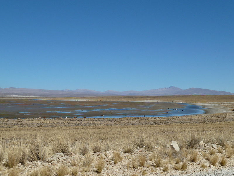
Passing one of the lagoons in the nature reserve

… a popular meeting point for the local cattle
Otherwise the area is pretty deserted

Leaving the high plateau, the road gets narrower – and as so often, the abyss is on the wrong side… ![]()

Ok, the route may not be as famous or as high as the Camino de la Muerte…

… but if you go over the edge, I would imagine that the result is pretty much the same

View back up the mountain

There may be a lack of safety barriers on Bolivian roads but some times they grant you a lay-by to recover from permanently holding your breath…

Although the vastness of the landscape elevates your mind, it can feel quite lonely on the Altiplano. You may meet only seven vehicles the whole day long but you never know in which bend this will happen. After another close encounter with a coach, I feel the constant strain taking its toll and start to count the kilometres to Tupiza down.
There lies a village in the valley below, pretty big and with well-built houses, but no road-sign provides the passing tourist with further information. Only when the settlement is behind me a name appears in the corner of my GPS – it was Yunchara. Phew, another 54 kilometres / 34 miles since Iscayachi.
The road still heads downhill and I reach a fertile river valley, lots of green and trees but I don’t stop any more, it’s getting late.

The Bolivians are constantly improving their road network and I come across many construction sites. The workers greet me friendly and some even cheer when I pass them – I think that’s because they are female, too.
An oncoming truck flags me down and the three young guys inside ask if I knew where the road was leading. Yunchara, great – that’s the place they want to reach today. Good luck, boys! Then the carretera raises again but this time it is a bit wider and I can finally stop by the side of the road, using the DRZ as a screen from other vehicles – even if you haven’t seen another human being for over an hour, you can bet that someone will pass just after you have pulled down your trousers… ![]()
Over some water and a biscuit I consider my options: progress is very slow, it’s already gone 16.00 hrs and Tupiza is still 75 kilometres (47 miles) away. The next town is Villazón, a mere 32 kilometres (20 miles) to go, so I may vote for the sensible option and call it a day there. The junction shouldn’t be far and right, after the next corner I can see a narrow track winding down into a deep valley – oh dear, this looks quite adventurous… Fortunately two elderly señores are sitting at the crossroads who I approach for advice.
Oh, that one, that’s just a camino a un pueblito, a path to a small village; the proper junction to Villazón is a bit further up on the Altiplano. One of the gentleman even draws a little map in the dirt. There should be a road-sign but many drivers miss it and carry on to Tupiza. Muchas gracias, señores, this was most helpful.
I reach the Altiplano and the road broadens; it’s corrugated but fast. The junction is clearly marked with obvious signs and after a while there is even tarmac! Still, the pista] is not finished yet and the traffic has to divert to the dirt road again occasionally but the last seven kilometres are beautiful smooth asfalto. Fantastic, I had almost forgotten what a paved surface feels like!

As Villazón lies on the border with Argentina near La Quiaca, where the famous Ruta 40 commences, there is the obligatory police checkpoint before you enter the town. After a little chat the officer waves me on and I can embark on my usual sight-seeing tour. Villazón is chaotic, buzzing with life, people and business, lots of traffic and noise. The sun is low and blinding, and I almost enter a one-way street in the wrong direction – sorry…
The South American Handbook recommends the Hotel Center but unfortunately they don’t have any vacancies – that’s a first on my journey. Hostal Plaza on the other side of the main square should be good as well, says the young man at reception. Ok, but they have run out of single rooms at 70 Bolivianos (£6.50) and can only offer a matrimonio, a double for 110 Bs including breakfast – just over £10.00. It’s already 18.00 hrs, it’s getting cold and dark and I’m absolutely knackered – go on then, let’s splash out!

The receptionist helps me carrying the luggage upstairs, then he leads me to the secure parking a few streets away. Gracias. After a hot shower I feel a lot better. Relaxing on the bed I read the chapter about altitude sickness in Jim Duff’s Pocket First Aid and Wilderness Medicine again: shall I take precautions or not? Villazón lies at 3,470m (11,155ft), Tupiza at 2,990m (9,810ft) and Uyuni at 4,400m (14,436ft). I have brought some acetazolamide with me but the drug has to be taken 24 hours before ascending to altitude and it can make you feel dizzy – not exactly what you want when conducting a motorcycle over the Andes. I will think about it one more day and possibly start the prophylaxis the next evening in Tupiza.
Conveniently, the Hostal Plaza has a restaurant in the basement and although it is completely empty, the waiters busy themselves to make me feel welcome and comfortable. Sopa fideo, noodle soup, and Milanesa, a paper-thin breaded meat fillet, are on the menu. After dinner I head to the next internet café where I find out that the whole of Villazón must depend on one single dial-up connection – it takes forever to upload six photos (out of the 29 shot today…) and after one hour I give up and leave the crowded, noisy place.
The neon display on the Plaza Mayor shows the current temperature: 4 degrees Celsius… ![]() Off to bed, and quickly!
Off to bed, and quickly!

Nice to hear from you again Ella .That trip sounded a bit hairy ! Hope your ok X